THE HISTORY OF ROCKCASTLE COUNTY
Rockcastle County, KY was formed in 1810 from primarily Lincoln and Madison Counties, with a small area on the southwestern edge coming from Pulaski County and a very small area on the east from Knox County. Portions of Rockcastle County were later taken to help form Laurel County in 1825 and Jackson County in 1858. About a quarter of the county is considered as part of the Daniel Boone National Forest.
The county has a wide range of terrain features, from the rugged hills near the Rockcastle River in the south, to the much flatter land in the northwest.
Perhaps the county's greatest historical significance derives from the roads leading through it. Two major thoroughfares, the Wilderness Road and Scaggs' Trace, ran through the county, ushering hundreds of thousands of pioneers into Kentucky in the late 1700s and early 1800s. For most families, the section which would become Rockcastle County wasn't a destintation–it was a part of a long journey to a hoped-for better life.
Of course, a few families did settle in the area. The standard is that Stephen Langford led the first settlers in the county in 1790. While Langford was a major figure in the early settlement, there were undoubtedly a few scattered settlers in the county prior to 1790, as shown by the early Lincoln County tax lists and perhaps by land grants prior to 1790. It's also not unreasonable to believe there were a few inns servicing the weary travelers established by enterprising fellows along both major roads through the county.
Land grants were issued in what was to be Rockcastle County at least as early as 1781. Most were to land speculators, notably Jacob Myers.
Native Americans used the Rockcastle area as they used much of Kentucky, as hunting grounds and temporary camps. There is evidence on the south section of the East Fork of Skeggs Creek and on Eagle Creek near the Rockcastle River of perhaps a more permanent inhabitance, at least of the establishment of returned-to encampments.
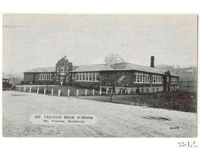
Mount Vernon, the county seat, was established about 1790. The original name for the settlement was White Rock, but it became known as Mount Vernon, named after George Washington's home, around 1810.
The railroad came through the county after the Civil War. For a time, both Pine Hill and Livingston were more important towns, and, in the case of the former, more populated, than Mt. Vernon. The railroad, and today's U.S. 25 now named Wilderness Road (formerly called the Dixie Highway), roughly follows parts of the early Wilderness Road through the eastern section of the county. Economic development activities thrived on the improved transportation systems, to the great benefit of the communities along them. Ultimately, Interstate 75 bypassed those long-established routes.
The western part of the county, especially the lower part of the Skeggs Creek watershed, never had the transportation advantages afforded by the improved infrastructure. Although used more heavily than the Wilderness Road early on, Scaggs' Trace was an incredibly rough path, with numerous difficult creek crossings. Other than coal extraction, there was no industry to speak of in the western section. Families living there were more reliant on farming and seemed to connect more with eastern Pulaski County families than with those who lived in Mt. Vernon, Pine Hill, or Livingston.
Virtually all local records (marriage, estate, court & land) were destroyed in the burning of the county courthouse in 1873.
Rockcastle County covers a land area of 318 square miles with an estimated population in 2005 of 16,712 persons. The topography of the area would appropriately be described as picturesque with wooded hills and valleys. About one-fourth of the county is in Daniel Boone National Forest. The most interesting geological feature is probably the Great Saltpeter Cave, which produced an important ingredient for gunpowder in the War of 1812.
The county seat of Rockcastle County, Mt. Vernon is located just off Interstate 75 at the intersection of U.S. Highways 25 (now named Wilderness Trail Road) and 150, 54 miles south of Lexington, Kentucky; 119 miles north of Knoxville, Tennessee; and 128 miles southeast of Louisville, Kentucky. Mt. Vernon named in honor of George Washington's home after first named White Rock.
Once known as the Great Wilderness and described as a "dark and gloomy forest with rushing mountain streams, acres of tree trunks laid low in a tangled mass by blow-downs and where log cabins were built and lived in temporarily by Indians" by Dr. Thomas Walker, the first white man known to visit the area in 1750, there is an interesting and rich history that led to the settlement and development of what we now know as Rockcastle County, Kentucky. Walker discovered the Cumberland Gap and associated trails that opened the area for hunters and other explorers. However, according to John Lair in his book Rockcastle Recollections (1991), it was some 13 years before the area would again be visited by white men. The next groups were hunters, one of whom was Charles Cox, for whom a prominent ridge is named, and Henry Skaggs, who is reported to have pursued a buffalo across Rockcastle River and found a creek that was later named for him. Other groups who followed the Elisha Walden party of hunters from Henry County, Virginia, included Squire Boone, Alexander Neely, Daniel Boone, and John Stuart.
Daniel Boone, probably the best known of this group, made several trips into the area and on one trip stopped off at a new settlement being established at Harrodsburg. It is here that he acquired a lot in what is considered the first settlement in Kentucky. According to Lair, "In the Boone Hollow and Red Hill section of Rockcastle County are to be found many legends concerning Daniel Boone and his presence there, at one time or another. Although many of the early efforts to establish settlements failed because of skirmishes with unfriendly Indians of the area or for other reasons, it is believed that the first house built and occupied by white men in the boundaries of the now Rockcastle County was about 1790."
Life was difficult in those frontier years, and survival in the wilderness depended upon one's ability to find enough food by hunting or fishing to support a family throughout the year. But the settlers made do with what they had, and some developed special skills and crafts that would lead to income from the making of barrels, churns, spinning wheels, shoes, etc., in addition to farming small plots of land carved out of the forests. However, as the levels of literacy and achievement dropped well below those of other parts of the country, the belief continued to grow that these mountain people were a "shiftless and inferior class of people" who happened to have settled here because their wagons had broken down on the trail and that, rather than go to the trouble of repairing the damage, they would just build a pole cabin and settle permanently. Actually, according to Lair, these early settlers were from some of the "most important families of the Old South and the educational deficiencies could be attributed to "lack of good roads and good schools and consequent [lack of] opportunities rather than lack of good bloodlines and heritage."
Coming by water (the Ohio River) and land through the Cumberland Gap and on other trails used by the earlier explorers and hunters, the area became populated with white settlers from various parts of the country. On June 1, 1793, Kentucky became a state; and by an act of the Kentucky legislature in 1809 to set up the county, Rockcastle County was approved on January 8, 1810. The first county courthouse was built of logs, but it and several other structures used for this function were destroyed by fires. These catastrophes destroyed many of the official records of the county and surrounding area, which may be the reason that there is no official written history of Rockcastle County.
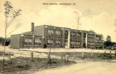
Although there were other settlements, the towns of Mt. Vernon, Brodhead, and Livingston seem to be the most prominent over time. Renfro Valley also emerged as an entertainment and tourist area in the late 1930s, and it continues to be recognized as that even today. Mt. Vernon, the county seat of Rockcastle County, is reported to have been founded at its location because of "Spout Spring," thought to be discovered by an unknown rider headed west in the late 1700s. Although the spring was touted for its purity and its attraction as a gathering place and was used for drinking water for many years, it was later found and reported in the 1900s that its source was surface runoff. According to an April 24, 1986, newspaper account of the Health Department's findings from testing the water, it "contained enough animal life to make an excellent soup by the addition of a little salt and pepper."
Although there are a number of churches in the county today, practically all of the older churches were Baptist, a religious faith that predominates the area today. Lair's book indicates that a Reverend John Lythe of the Church of England was supposed to have conducted services in Boonesville, but it was the Baptists who were first in Kentucky. As early as 1776, a Reverend William Hickman traveled the area on behalf of the Baptists, and later the "traveling church" concept further solidified that religious belief in the region. Today, the predominant religious faiths in the area are Baptist, Pentecostal, and Christian.
|
|